
all creatures great and small
9/16/2018
We are going to take the time in this post to retrace our footsteps from our current home near Medicine Bow National Forest back to Custer State Park and Black Elk Peak. In the ensuing week and a half following our departure from Custer, we have come to understand more fully how important the role of nature in this journey has become. Yes, the people we have met out in these parts have been warm, welcoming, and interesting. But as we have found ourselves walking paths through woods and along passes and up peaks, the draw to the natural world has increased. The power of nature to ground and to heal as it challenges and inspires has become increasingly apparent to us.


A Hike Up to where spirits soar
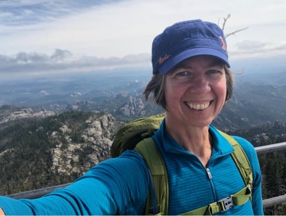
Even before we started, the hike up to Black Elk Peak seemed important. Important because of what it is and what it signifies. It has historically been a place of spiritual significance for the Native Americans, and, given each of our reflective experiences on the history and current conditions for Native Americans here, a hike up Black Elk Peak seemed fitting. The peak is also the highest point east of the Rockies and west of the Pyrenees. We knew it would challenge us. We knew it would inspire us. It did not disappoint.


A turning point
We had done one other hike, deemed strenuous. That hike had some beautiful pieces, but we were ill-prepared for it. For Black Elk Peak, we’d done a bit more research, and were thus much more mentally and physically prepared for what we would meet on the journey to the top. What we were not prepared for, however, was the pleasant surprise of the realization that this hike marked a turning point for us on our life’s journey out here on the road. We had understood that natural spaces would be important to us, that we would find beauty in the North American landscapes. We had not fully grasped until this point how much we would utterly need those natural spaces, to connect with them in order to connect with ourselves.


a greater connection
The connection is about more than what we view from the windows of Knight, or from our wanderings around the campsites we inhabit. It is about more than pushing your body to get to the top, though there is that glorious sense of accomplishment in discovering what your body can do and that sense of wonder at the views from above. It is about truly being present where you are. Not just looking around you, but truly seeing what you are a part of, taking in the grandeur of broad views along with noticing the tiniest of wildflowers still blooming among the trees or the spiders that crawl across your path, and everything in between, and realize that they, along with you, make up the Big Picture that is our world.
Peace.
Des